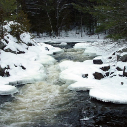
Within the Township are smaller urbanized areas such as the Village of Apsley, and the hamlets of Big Cedar, Burleigh Falls, Glen Alda, Mount Julian, Stoneyridge and Woodview.
About North Kawartha
North Kawartha has a land area of 746.35 kilometres. It is located midway between the City of Peterborough and the Town of Bancroft, which both offer all the amenities of larger urban centres.
We provide services to a population of approximately 2,877 year round residents and approximately 12,000 seasonal residents for a total population of approximately
14, 877 residents.
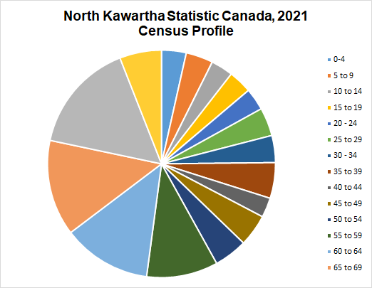
The population grew by 16.1% between the 2016 and 2021 censuses.
(2021, Statistics Canada Census Profile)
A united and healthy community connected to our natural heritage.
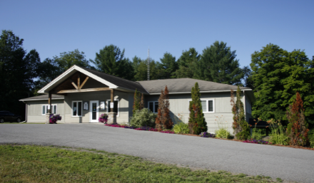
Our community includes a Municipal Office, Elementary school, Child Care, Canada Post Office, Places of Worship, 2 Golf Courses, Trails, 2 Public Library locations, a NHL regulation sized ice pad (home to the North Kawartha Knights, a junior hockey team playing in the Jr. C Central League of the Ontario Hockey Association), 3 Community Centres, one with a Fitness Centre, 2 Fire Stations, and 2 Transfer Stations and weekly curbside garbage and recycling collection.
High speed internet is available throughout many areas in North Kawartha and is expanding.

The Township of North Kawartha is a municipal government, formed in 1998 through an amalgamation of the former municipalities of the Township of Burleigh and Anstruther and the Township of Chandos.
North Kawartha at a Glance
- North Kawartha has a dominant workforce in construction, retail trade and accommodation and food services.
- An unemployment rate of 8.5%
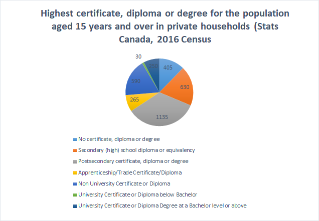
Statistics from Statistics Canada, 2016 Census Profile
Demographic Data and Quick Facts
- Population (Permanent, 2877)
- Population (Seasonal approximately 12,000-14,000)
- Total Private Dwellings - 3,693
- Private Dwellings occupied by usual residents - 1,364
- (2) Provincial Parks
- Kawartha Highlands Signature Site
- Petroglyphs Provincial Park
- Average Age 51.8 years (2021 census)
- Labor force Participation Rate 59.2% (Ontario)
- Unemployment Rate 13.1%
- Median total income in 2015 among recipients: 29,419
- Median total income of economic families in 2015: 70,766
Retail
- Hardware & Building Supply
- Grocery
- Pharmacy
- Clothing and Specialty Gift
- LCBO & LCBO Outlets
- Local Artisans & Makers
Construction
- Custom Home building, renovations, and additions
- Carpentry work
- Electrical work
- Mechanical work
- Plumbing work
- Landscape and Site Development
- Road Construction & Maintenance
- Aggregate Supply
- Equipment Rental
Seasonal and Recreational Amenities
- Accommodations & Resorts
- Marinas
- Golf Courses
- Restaurants
- Food Trucks
- Outdoor Adventure
- Cross-county skiing
- Snowmobiling
- Fishing and hunting
The Township of North Kawartha begins at Burleigh Falls in the south end and ends in Glen Alda and just south of Bancroft, ON.
The main highway through the Township is Highway 28. County Roads 504 and 620 run through the Township as well.
From Toronto, take Highway 401 to Highway 35/115. Proceed north on Highway 115 to Highway 28 North. Highway 28 North will take you through the centre of the Township.
Map of North Kawartha (pdf)

Sign up to our Newsletter
Subscribe to receive your choice of news, notices, and weekly events directly to your email.